Coal Mine Water Prevention and Control Case Study: How the AML920 Groundwater Flow Velocity and Direction Meter Enables Accurate Groundwater Flow Field Monitoring
1. Why Is Groundwater Flow Field Monitoring Essential for Coal Mine Water Prevention and Control?
Water prevention and control in coal mines is essential for ensuring safe mining operations and maintaining normal mine operation. It runs throughout the entire process of mine construction, production, and long-term monitoring. The main tasks include hydrogeological investigations, water exploration and drainage, waterproofing and grouting for water sealing, and groundwater dynamic monitoring. Due to the complex hydrogeological conditions of coal mines, water prevention and control work typically involves long project cycles, extensive monitoring areas, and numerous boreholes. Some projects require coordinated monitoring and treatment through multiple boreholes.
Coal mine water prevention and control must adhere to the fundamental principles of “prediction and forecasting, exploration wherever there is doubt, exploration before excavation, and treatment before mining.” Comprehensive measures should be adopted, including exploration, prevention, plugging, diversion, drainage, interception, and monitoring. Among these measures, accurately determining groundwater flow velocity, flow direction, and their spatial distribution is an important technical step in analyzing groundwater migration patterns, identifying potential water-conducting pathways, and evaluating the effectiveness of grouting for water sealing.
Groundwater research materials from the U.S. Geological Survey (USGS) also emphasize that determining groundwater flow direction, flow velocity, and aquifer hydraulic characteristics requires a comprehensive analysis of groundwater levels, hydraulic gradients, and field monitoring data. This technical approach also provides a reference for groundwater flow field investigation and monitoring in coal mines.
Reference: USGS Groundwater Technical Procedures, https://pubs.usgs.gov/publication/tm1A1
2. Major Challenges in Coal Mine Water Prevention and Control
1. Complex Groundwater Sources and Interactions Among Multiple Aquifers
Groundwater sources in coal mining areas are complex. In some mines, mining depths reach hundreds of meters or even more than 1,000 meters, potentially involving different types of groundwater, such as shallow groundwater, fracture water, and confined groundwater.
Meanwhile, precipitation infiltration, recharge from rivers and lakes, and hydraulic connections between different aquifers may all affect groundwater distribution and migration. Relying solely on a single groundwater level measurement is often insufficient to fully determine the actual groundwater flow conditions.
Therefore, coal mine water prevention and control should not focus only on groundwater level changes. Information such as groundwater flow velocity, flow direction, geological structures, and aquifer distribution must also be considered to further analyze groundwater flow field characteristics.
2. Complex Geological Structures and Uncertain Water-Conducting Pathways
Geological features such as faults, fracture zones, karst collapse columns, and water-conducting boreholes may serve as pathways for groundwater migration. Some of these pathways are concealed, and their water-conducting capacity may change with mining disturbances, geological changes, and variations in water pressure.
Inaccurate assessments of groundwater flow fields may affect the layout of water exploration and drainage boreholes, the design of grouting treatment plans, and the evaluation of water-sealing effectiveness.
Therefore, coal mine water prevention and control requires the integration of hydrogeological investigations, borehole monitoring, and verification of treatment results, using actual monitoring data to support engineering decisions.
3. Applications of the AML920 Groundwater Flow Velocity and Direction Meter in Coal Mine Water Prevention and Control
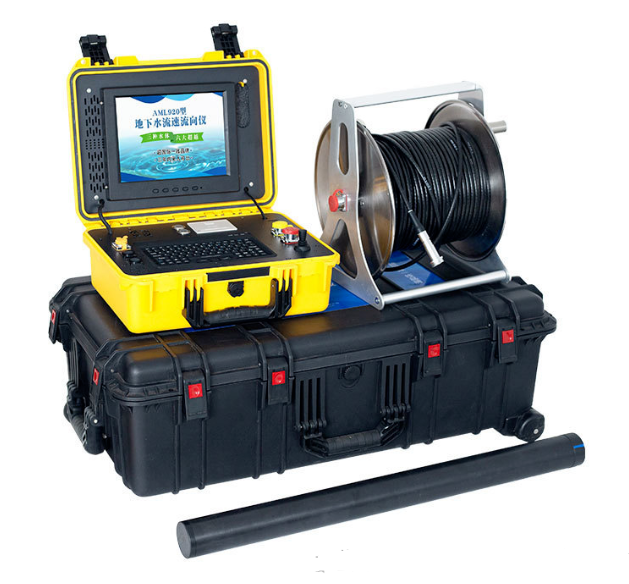
In recent years, the AML920 Groundwater Flow Velocity and Direction Meter has been used in field monitoring related to coal mine water prevention and control. Its main applications include groundwater flow field investigations, flow field measurements after monitoring wells have been completed, and comparisons of groundwater flow characteristics before and after grouting for water sealing.
Based on existing field applications, the AML920 offers practical value in the following areas:
- Flow field investigations after monitoring well completion: After a monitoring well has been completed and developed, groundwater flow velocity and direction can be measured promptly, providing data for analyzing local groundwater flow fields.
- Comparisons before and after grouting for water sealing: Comparing monitoring results before and after treatment provides a basis for analyzing whether groundwater flow characteristics have changed.
- Evaluation of water-sealing isolation zones and waterproof curtains: Monitoring at appropriately selected locations can help assess changes in groundwater flow characteristics within treated areas.
- Development of local groundwater flow field models: By combining flow velocity and direction measurements from multiple monitoring points with other hydrogeological data, the instrument provides field measurement data for local flow field analysis and model development.
Compared with certain groundwater flow field investigation methods that require multiple monitoring wells to be completed before measurements can be conducted collectively, the AML920 allows single-borehole measurements to be performed promptly after a monitoring well is completed. This helps integrate groundwater flow field monitoring into the well construction workflow and reduces the waiting time for obtaining the first batch of flow field data.
It should be noted that a single-borehole measurement reflects the groundwater flow characteristics at the corresponding measurement point under the specific test conditions. To establish a representative groundwater flow field model for a mining area, comprehensive analysis of multiple measurement points, aquifer structures, groundwater levels, and other hydrogeological data is still required.
4. Working Principle of the AML920 Groundwater Flow Velocity and Direction Meter
The AML920 Groundwater Flow Velocity and Direction Meter uses a particle microscopic identification video algorithm. By analyzing the movement of identifiable particles in water, it obtains information about groundwater flow direction and velocity.
The instrument uses a single-borehole measurement method and can measure groundwater flow characteristics at a target depth within a monitoring well. During monitoring, an appropriate measurement depth can be selected according to the well structure, screen location, and aquifer distribution.
Introducing this instrument during monitoring well construction helps obtain groundwater flow field data promptly. These data can then be combined with groundwater level observations, geological logging, and other hydrogeological investigation results to provide a basis for subsequent water prevention and control engineering design and effectiveness evaluation.
5. Field Operating Procedures for the AML920 Groundwater Flow Velocity and Direction Meter
After a monitoring well has been completed and developed, groundwater flow velocity and direction measurements can be carried out according to field conditions. The specific operating procedures are as follows.
Step 1: Instrument Calibration
Before use, calibrate the AML920 Groundwater Flow Velocity and Direction Meter to reset the direction detection to zero and ensure that the instrument enters the measurement state in accordance with the prescribed operating procedures.
Step 2: Lower the Probe and Allow the Water to Recover
Lower the AML920 probe to the location of the monitoring well screen. The middle section of the screen is preferred as the measurement position. After the probe reaches the target position, leave it stationary for approximately 15 minutes to allow the water body and measurement environment to stabilize.
The actual stabilization time should be determined based on field disturbance, instrument operating requirements, and the recovery state of the water body.
Step 3: Conduct Groundwater Flow Velocity and Direction Monitoring
After completing the preparations above, start monitoring. Under normal circumstances, approximately 50 minutes of monitoring at a single measurement point is required to obtain data representing groundwater flow velocity and direction at that location.
The actual monitoring duration should be determined according to field hydrogeological conditions, data stability, and instrument operating requirements. If necessary, the monitoring time should be extended or the measurement repeated.
Step 4: Conduct Layer-by-Layer Monitoring in Multiple Aquifers
If a monitoring well involves multiple aquifers, measurement results from a single depth should not simply be used to represent the entire well interval. Appropriate measurement positions should be determined at different depths according to the well structure, screen arrangement, and aquifer distribution, and monitoring should be conducted layer by layer.
Obtaining groundwater flow velocity and direction data at different depths helps further analyze flow characteristics across different layers and provides a reference for identifying local hydraulic connections.
Step 5: Organize the Data and Conduct Comprehensive Analysis
After measurements are completed, the results should be organized and analyzed in conjunction with measurement point coordinates, measurement depths, monitoring times, well structure, aquifer information, and groundwater level data collected during the same period.
When sufficient measurement points and relevant hydrogeological data are available, a local groundwater flow field map can be prepared to analyze groundwater flow directions and their spatial differences, providing data support for optimizing coal mine water prevention and control plans.
6. What Are the Application Advantages of the AML920 Compared with Traditional Groundwater Flow Field Investigation Methods?
1. Bringing Flow Field Monitoring Forward to the Monitoring Well Construction Stage
The AML920 uses a single-borehole measurement method and can perform measurements after a monitoring well has been completed and developed. Compared with work arrangements that require all monitoring wells to be completed before measurements can be conducted collectively, this approach enables flow field information from individual measurement points to be obtained earlier.
For projects that require a monitoring network to be constructed in stages, this approach helps shorten the time needed to obtain the first batch of monitoring data and provides a reference for the subsequent placement of monitoring points.
2. Reducing Dependence on Preliminary Multi-Borehole Measurements
Traditional groundwater flow field investigations often determine groundwater flow direction by comprehensively analyzing groundwater level data from multiple monitoring wells and other hydrogeological information. The AML920 directly obtains flow velocity and direction data at individual measurement points, supplementing traditional monitoring methods.
This does not mean that multi-borehole monitoring can be completely eliminated. Instead, single-borehole direct measurements can be combined with multi-point monitoring according to engineering requirements to make flow field investigations more targeted.
3. Helping Verify Existing Assessments of Groundwater Flow Direction
In some projects, existing assessments of groundwater flow direction are based primarily on groundwater level observations and equipotential contour analysis. Actual groundwater movement is also affected by factors such as formation permeability, fracture distribution, and local hydraulic conditions.
Comparing the AML920’s measured flow velocity and direction data with existing equipotential contour analysis results helps identify local flow field differences. It also allows further verification of whether monitoring wells are located in representative hydrogeological positions, helping avoid one-sided conclusions based solely on limited groundwater level data.
4. Providing Monitoring Evidence for Evaluating Grouting and Water-Sealing Effectiveness
After grouting and water-sealing work is completed, repeat measurements can be conducted at suitable monitoring points. Groundwater flow velocity and direction data collected before and after treatment can then be compared.
If the monitoring results show significant changes, the causes can be further analyzed in conjunction with the grouting area, geological structures, groundwater levels, and other monitoring data. This provides a reference for assessing the actual effectiveness of water-sealing isolation zones or waterproof curtains.
It should be noted that changes in groundwater flow fields cannot serve as the sole basis for engineering acceptance. The final evaluation must comprehensively consider project design requirements, relevant technical standards, and other necessary inspection results.
7. Field Applications of the AML920 Groundwater Flow Velocity and Direction Meter in Coal Mines
According to existing field application materials, the AML920 Groundwater Flow Velocity and Direction Meter has been used in several mining areas in Inner Mongolia, Shaanxi, and Shanxi.
In some projects, groundwater flow velocity and direction monitoring has been scheduled alongside monitoring well construction. Measurements are conducted promptly after well completion, and data from multiple monitoring points are combined to analyze local groundwater flow field characteristics.
This working approach helps obtain measured flow field information during the initial construction of a monitoring network, further improve local groundwater flow field analysis, and provide a basis for subsequent monitoring point placement, research into groundwater migration patterns, and evaluation of water prevention and control engineering effectiveness.
According to field application feedback, the AML920 has achieved good application results in groundwater flow field monitoring for coal mines. The monitoring accuracy, improvement in efficiency, and cost savings achieved in specific projects should be determined based on the corresponding inspection reports, comparative data, and acceptance documentation.
For projects requiring mine hydrogeological investigations, comparisons of grouting and water-sealing effectiveness, or local groundwater flow field analysis, the AML920 can serve as a technical tool for monitoring groundwater flow velocity and direction, used in conjunction with conventional groundwater level observations and other hydrogeological investigation methods.
8. Frequently Asked Questions (FAQ)
FAQ 1: Why Is Groundwater Flow Velocity and Direction Monitoring Necessary for Coal Mine Water Prevention and Control?
Groundwater flow velocity and direction reflect the actual groundwater flow characteristics at a measurement point. Analyzing these data together with groundwater levels, geological structures, aquifer distribution, and borehole information helps identify potential water-conducting pathways, analyze groundwater migration patterns, and provide a basis for water exploration and drainage design and the evaluation of grouting and water-sealing effectiveness.
FAQ 2: What Measurement Method Does the AML920 Groundwater Flow Velocity and Direction Meter Use?
The AML920 uses a single-borehole measurement method. It analyzes the movement of identifiable particles in water using a particle microscopic identification video algorithm to obtain groundwater flow velocity and direction information at the measurement point.
FAQ 3: How Long Does Groundwater Flow Velocity and Direction Monitoring with the AML920 Usually Take?
According to the existing field operating procedures, after the probe is lowered to an appropriate position within the well screen, it typically needs to remain stationary for approximately 15 minutes before monitoring begins. Monitoring then takes approximately 50 minutes.
The actual duration should be determined according to water recovery conditions in the field, data stability, and instrument operating requirements.
FAQ 4: Can the AML920 Be Used to Monitor Multiple Aquifers?
Layer-by-layer measurements can be conducted according to the monitoring well structure, screen arrangement, and aquifer distribution. When multiple aquifers are involved, appropriate measurement depths should be determined separately. Data from a single measurement point should not be used directly to represent all aquifers.
FAQ 5: Can the AML920 Be Used to Evaluate Grouting and Water-Sealing Effectiveness or Waterproof Curtains?
The AML920 can be used as an auxiliary monitoring tool. Comparing groundwater flow velocity and direction data before and after treatment helps analyze local flow field changes. However, the final evaluation must consider engineering design requirements, geological conditions, and other necessary inspection data. Conclusions should not be based solely on measurements from a single instrument.
FAQ 6: How Can Groundwater Flow Velocity and Direction Data Support Coal Mine Water Prevention and Control Decisions?
Groundwater flow velocity and direction data can be combined with groundwater levels, geological structures, borehole information, and aquifer distribution to analyze local groundwater flow fields, verify existing assessments of flow direction, help identify monitoring priorities, and provide technical references for water exploration and drainage, grouting and water sealing, and treatment effectiveness evaluation.
For complex mining areas, multiple monitoring points should be appropriately distributed, and different types of hydrogeological data should be analyzed comprehensively to avoid one-sided conclusions based on a single measurement point.
FAQ 7: Which Coal Mine Water Prevention and Control Projects Are Suitable for the AML920?
The suitability of the AML920 can be evaluated according to field conditions for projects involving groundwater flow field investigations after monitoring well completion, analysis of groundwater flow characteristics at different aquifer depths, comparisons before and after grouting and water-sealing treatment, and the development of local groundwater flow field models.
Conclusion: Choose Professional Groundwater Monitoring Equipment to Improve the Efficiency of Coal Mine Water Prevention and Control
Coal mine water prevention and control must be based on accurate hydrogeological investigations and reliable field monitoring data. Understanding groundwater flow velocity and direction helps analyze groundwater migration patterns, identify local flow field differences, and provide important references for water exploration and drainage, grouting and water sealing, and the evaluation of waterproofing engineering effectiveness.
The AML920 Groundwater Flow Velocity and Direction Meter uses a single-borehole measurement method. It can monitor groundwater flow velocity and direction after a monitoring well has been completed. Following approximately 15 minutes of stationary preparation and approximately 50 minutes of monitoring at a single point, it provides data for analyzing groundwater flow characteristics at the measurement location.
In field applications across several mining areas in Inner Mongolia, Shaanxi, and Shanxi, the instrument has provided an additional technical approach for groundwater flow field investigations, local flow field analysis, and comparisons before and after treatment.
For coal mine water prevention and control, groundwater flow field investigations, and hydrogeological monitoring requirements, AIMOLI offers the AML920 Groundwater Flow Velocity Meter and Groundwater Direction Meter to provide technical support for monitoring groundwater flow velocity and direction in relevant projects.
If you have any of the above requirements, please feel free to contact us.
